 |
Before you take off, punch up the Bearing-up Plan View of
"JFK" in to see the layout of the runways with right-hand traffic arrows for runways 13 L and 13 R. Plan View allows you to see the layout of many airports in ARGUS 5000 and 7000's user-replaceable database. |
 |
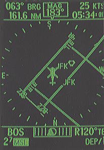
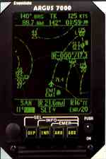
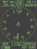
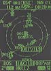
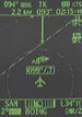
At takeoff, switch to DEParture mode. This screen shows your position at JFK airport (Note the helicopter symbol: An optional database provides Public, Private and Military Heliports, including Hospitals for EMS missions.) The upper window shows a compass rose and numerical heading display, plus bearing, distance and groundspeed. The lower window shows a waypoint identifier, a digital or analog
CDI, track error, or digital ADF. Minimum Safe Altitude (derived from VFR Sectionals) is also shown, as is the ARGUS mode, the range and actual time of arrival at your waypoint or destination. |
 |
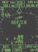
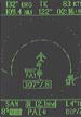
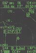
In this screen you're positioned near "JFK's" Runway 4 R. (ARGUS accuracy depends on your LORAN C, GPS, or other long-range navigation source, of course.) In this DEParture mode screen,
"JFK" has been selected to display the bearing and distance from your aircraft to the airport. Pressing SELect shows the bearing (or radial from
VOR-type facilities) and distance to any facility on the screen. The nearest facility is SELected first, then the next nearest, etc. |
 |
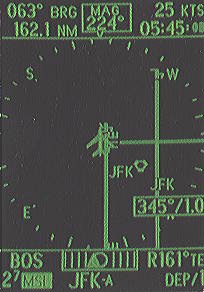
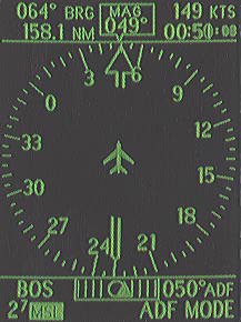
Tight on panel space? No problem. As shown here, the ARGUS 5000 and 7000 can connect with most ADF receivers to produce an ADF RMI display if integrated with a compatible
D.G. or slaved compass system. |
 |
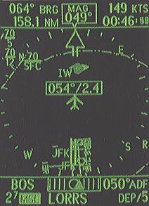
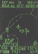
The ADF bearing pointer can also be overlayed with map graphics as in this screen (this mode isn't approved for IFR NDB approaches, however). Upon selecting a facility such as
"LORRS," ARGUS shows a digital bearing and distance readout that corresponds to the direction of the bearing pointer to the received
NDB. Note the TCA boundaries with ceiling and floor annotations. More features that make navigating easier. |
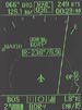 |
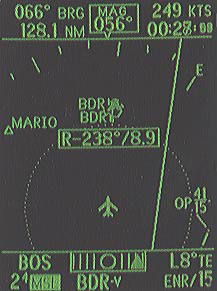
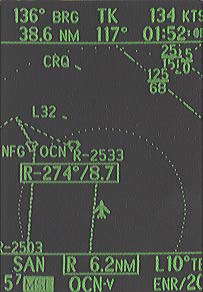
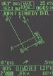
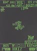
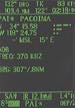
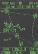
ENRoute mode is shown in this screen. Note that courseline and the ARSA on the right with its ceiling and floor annotations. The Bridgeport
(BDR) VOR, which has been selected, is one of more than 6,500 NAVAIDs in the Argus database. Information about any selected facility can be obtained at the touch of a button. |
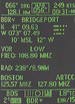 |
Note the details on BDR in this screen, including the ARTCC communications frequencies. |
 |
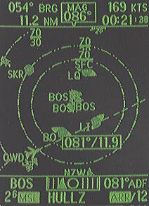
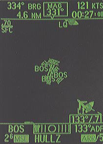
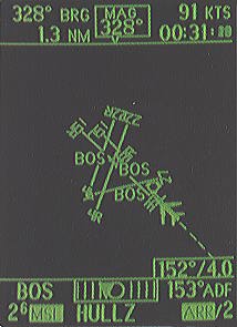
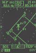
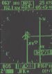
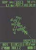
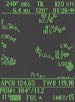
ARRival mode resembles a variable scale "approach plate" with a moving aircraft and stationary map. During visual and instrument approaches, ARGUS can show you how the runway will appear when you break out at minimums. This and the following two screens show the AUTOmatic ARRival feature adjusting screen ranges as you get closer to Logan Airport. The dashed line is the ADF "bearing line" which emanates from the moving aircraft. |
 |
Refer to text above. |
 |
Refer to text above. |
 |
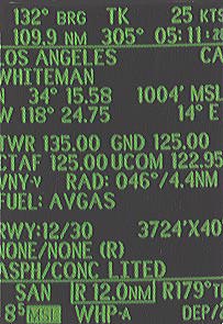
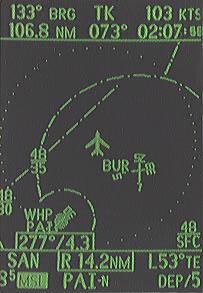
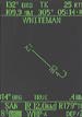
INFOrmation screen for Los Angeles' Whiteman airport, "WHP," shows the location, airport elevation, communications frequencies, fuel available, runway length, width, lighting and traffic pattern direction. |
 |
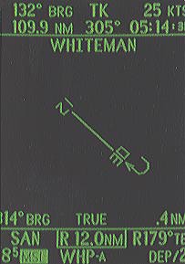
This is a Plan View of the airport runway. The Argus 3000 puts all this data and more at your fingertips.
|
 |
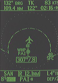
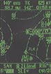
This is a track-up view of your aircraft departing WHP. (ARGUS 3000 orients to LORAN or GPS track only, since it cannot interface with a
D.G. or slaved compass like the ARGUS 5000.) Note the airport with its identifier and runway headings. As the range is changed, ARGUS adjusts the length and width of each runway to scale. The NDB
"PAI" has been selected and the lower window displays a bearing and distance readout to it. |
 |
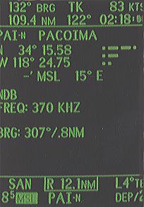
Information about "PAI" is shown here. Note the Morse code identifier, NDB frequency, and continuously updated bearing and distance.
|
 |
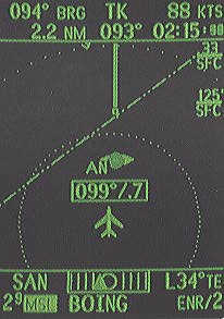
"BUR" (Burbank Airport) appears here. Your position is within the Burbank
ARSA. When you fly with ARGUS, you always know your relationship to SUAs - without bothersome alert
annunciators. The real-time Moving Map Display makes penetrating and circumnavigating SUAs safe and easy. |
 |
This screen shows your position at the perimeter of the Los Angeles TCA enroute to your destination at San Diego's Lindbergh Field.
"SLI" VORTAC has been selected and ARGUS 3000 shows a radial and distance readout from it. ARGUS 3000's ENRoute screens range from 2 to 240 nautical miles. |
 |
Observe the Restricted Area in this screen. It is one of the many SUAs which ARGUS depicts. Prohibited, Alert, Warning, Military Operating Areas, and ADIZ boundaries are included as well as ARSAs and TCAs with their associated ceilings and floors. All SUAs except Prohibited can be eliminated from every normal mode of operation at your
discretion. |
 |
The arrival mode shows your position as a moving aircraft symbol on a North-up stationary map, just like on the ARGUS 5000. Your destination airport or other terminal facility is defined by the next waypoint or destination you entered into the LORAN C or GPS. |
 |
If you prefer, just select DEParture or ENRoute for a moving map display, as shown here. The same on-screen graphics and information are available.
|
 |
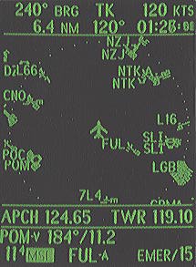
This screen shows the one ARGUS mode we hope you'll never have to use - the EMERgency function. Bearing and distance to the nearest airport, appropriate communications frequencies, and distance and radial from the nearest VOR facility replace the navigation information previously displayed in the upper and lower windows. You select suitable airports from the ARGUS database by specifying minimum runway length and surface type, lighting and whether or not you need a precision approach. The ARGUS displays only airports with those specifications - this includes both Private and Military airports, even if you have deselected them from the normal ARGUS modes. Selectable ranges are from 102 to 1 nautical mile. |